- EBC Home
- Subjects
- Index
- About the EBC
- Using the EBC
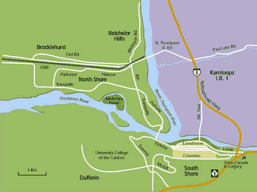
- Maps
- Feature Articles
- Videos
- BC Facts
- For Teachers
- French Language Resources
- Books about BC
- BC Links
![]()
![]()
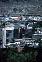
Kamloops

KAMLOOPS lies at the confluence of the N and S THOMPSON rivers, 325 km from VANCOUVER. It is the commercial and administrative centre of the south-central Interior and the third-largest community outside the Lower Mainland. The name is a variation of T'kumlups, a SECWEPEMC (Shuswap) word meaning "meeting of the waters." The Secwepemc were the original inhabitants. In 1811 David Stuart, a FUR TRADER with the PACIFIC FUR CO (PFC), arrived from the coast to trade. The following year he returned to establish a post. He was joined that fall by a party of NORTH WEST CO (NWC) traders, led by Joseph Larocque. In 1813 the NWC bought out the PFC and its post, Fort Thompson, became the centre of the trade. In 1821 the HBC took over the post, moved it from time to time, then closed its fort in 1893 and moved to a downtown store. A community began to develop during the GOLD RUSH period of the 1860s. The CATTLE INDUSTRY was established to feed the miners and subsequently the railway camps. With the arrival of the CPR in 1885, and the designation of Kamloops as a railway divisional point, the community boomed. Incorporated as a city in 1893, Kamloops expanded in 1967 and again in 1973 to include the surrounding suburbs. Fruit and vegetable growing flourished on the fertile flatlands next to the river (see AGRICULTURE), and from WWI, canning, especially of tomatoes, was an important industry. A period of prosperity followed WWII, symbolized by the flamboyant career of Rev Phil GAGLARDI, local MLA and minister of highways in the SOCIAL CREDIT government. By the 1970s growth had slowed. At the end of the 20th century Kamloops remained the centre of the province's ranching industry, but MINING and the FOREST INDUSTRY had become more important, and the city had a PULP mill and a COPPER SMELTER. Long known for its TROUT fishing, Kamloops attracts a growing number of TOURISTS in all seasons, especially since the completion of the COQUIHALLA HWY in 1986 reduced driving time to the coast. It is the site of the main campus of Thompson Rivers University, formerly the University College of the Cariboo.
Population: 80,376 (2006)
Rank in BC: 12th
Population increase since 2001: 4%
Date of incorporation: city 1 July 1893
Land area: 311.42 sq km
Location: Thompson–Nicola Regional District
Economic base: transportation, lumber, agriculture, tourism, cattle ranching, mining, manufacturing