- EBC Home
- Subjects
- Index
- About the EBC
- Using the EBC
- Maps
- Feature Articles
- Videos
- BC Facts
- For Teachers
- French Language Resources
- Books about BC
- BC Links
![]()
![]()
Rocky Mountains
ROCKY MOUNTAINS, the largest mountain range in N America, runs almost the entire length of BC, about 1,200 km from the US border to just shy of the Yukon border. The Rockies were formed about 120 million years ago when what was then the western edge of N America collided with other land masses, compressing the rock and causing it to fold, fracture and pile up (see CORDILLERA). From the US border to the vicinity of Kakwa Pass (well north of Jasper) they form the boundary between BC and Alberta. At Kakwa they continue, trending northwesterly, while the border veers straight north along the 120th degree of longitude. As a result the northeast corner of BC lies on the other side of the mountains. To the west the Rockies are flanked by the ROCKY MT TRENCH; on the east they descend into the rolling foothills of Alberta. The highest peaks are topped by the remnants of the great glaciers that millions of years ago scoured N America, most notably the COLUMBIA ICEFIELD (see also GLACIATION). The highest peak in the BC Rockies is Mt ROBSON at 3,954 m, followed by Mt Columbia (3,747 m) and MT ASSINIBOINE (3,618 m). As well as a physical barrier, the mountains have thrown up a psychological barrier between BC and the rest of Canada. They are a symbol of BC's uniqueness and separateness.
While FIRST NATIONS people crossed and re-crossed the mountains to trade, hunt and make war, the first Europeans to cross were Alexander MACKENZIE and his party in 1793, using the headwaters of the PEACE R as an avenue into the province. The mountains were subsequently explored by FUR TRADERS seeking practicable routes for transporting furs and supplies, and later by surveyors laying out the routes of the transcontinental railways. The CPR chose KICKING HORSE PASS as the route for its main line, leading to the development of the middle ranges of the mountains as a popular TOURIST destination. Four national parks—Jasper, Banff, YOHO and KOOTENAY—now form a huge reserve that was declared a UNESCO WORLD HERITAGE SITE in 1985 (see PARKS, NATIONAL). More recently several million hectares of the Northern Rockies, an area well known for its abundance of wildlife, have been set aside in protected zones. In the south the CPR completed a line through CROWSNEST PASS in 1898, opening that area to the development of its rich mineral resources. COAL mining continues to be important in the SPARWOOD–ELK R area. The GRAND TRUNK PACIFIC RWY used the YELLOWHEAD PASS west of Jasper as its route to the Pacific, and all 3 railway passes are now used by major highways as well. See also ROADS AND HWYS.
-
Video
-
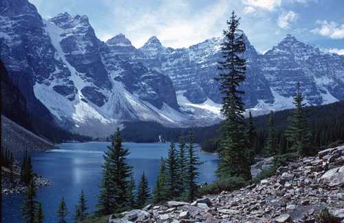
 Moraine Lake framed by the Rocky Mountains. Courtesy Reimut Lieder/Image Makers
 -
Internet links