- EBC Home
- Subjects
- Index
- About the EBC
- Using the EBC
- Maps
- Feature Articles
- Videos
- BC Facts
- For Teachers
- French Language Resources
- Books about BC
- BC Links
![]()
![]()
Vancouver Island
VANCOUVER ISLAND, 31,284 sq km, is Canada's tenth-largest island and the largest on the Pacific Coast of N America.
Physical Geography
The exposed top of a submerged mountain system, it lies parallel to the continent on a northeast–southeast axis, extending 460 km from JUAN DE FUCA STRAIT to Queen Charlotte Strait. JOHNSTONE STRAIT in the north and GEORGIA STRAIT in the south separate it from the BC mainland. A rugged spine of mountains rises to altitudes in excess of 2,000 m, including GOLDEN HINDE (el 2,200 m), the Island's highest peak. These mountains separate a rocky, deeply indented west coast from the coastal lowlands and milder climate of the east coast. Deep FJORDS, the longest of which are ALBERNI INLET, MUCHALAT INLET and the various arms of QUATSINO SOUND, almost bisect the Island, which has an average width of 50 km. Its mountains also shelter VANCOUVER and the ESTUARY of the FRASER R from the hurricane-force storms that regularly lash its exposed outer coast. Popularly known as "the Graveyard of the Pacific," the Island's treacherous southwest coast has been the scene of more than 200 shipwrecks. A lifesaving trail built for castaways in the 19th century is now the WEST COAST TRAIL, a unit of PACIFIC RIM NATIONAL PARK RESERVE and one of Canada's most popular wilderness hikes.
HENDERSON LK, near PORT ALBERNI, is the wettest spot in N America, with an average annual precipitation of 6,655 mm; it set a N American rainfall record in 1997 with 8,997.1 mm of precipitation. Vegetation on the west coast is characterized by shorepine bogs and dense temperate RAIN FORESTS of HEMLOCK, CEDAR and SPRUCE; these forests contain some of the largest and oldest trees in the world (see also TREES, GIANT). On the east coast, by contrast, the climate is classified as Mediterranean and rated the least severe in Canada. More than 90% of the Island's 671,000 inhabitants (18% of the provincial total) live in this drier, milder climatic zone, which is dominated by DOUGLAS FIR and, in the southern half, ARBUTUS and Garry OAK. Some of these landscapes are protected in a series of major parks, the most important being Pacific Rim National Park Reserve and STRATHCONA, BROOKS PENINSULA and CAPE SCOTT provincial PARKS. Most watersheds on the Island are drained by a series of short, steep river systems, providing habitat for once abundant SALMON, STEELHEAD and both anadromous and resident TROUT. Among the best-known rivers are the COWICHAN (a BC HERITAGE RIVER), Nanaimo, Englishman, Qualicum, Oyster, PUNTLEDGE, CAMPBELL, Nitinat, San Juan, Gold, and NIMPKISH rivers.
History
The Island's first human settlements occurred in the estuaries of these rich salmon streams. Although the ARCHAEOLOGICAL record is still being interpreted, it seems clear that aboriginal peoples from 2 major linguistic groups settled the Island many thousands of years ago (see PREHISTORY). These speakers of SALISHAN and WAKASHAN FIRST NATIONS LANGUAGES developed a complex village-based tribal culture that was rich in art and material wealth; rank, status and ceremony played significant roles. The aboriginal population at time of contact is unknown but during the 19th century repeated epidemics reduced it by two-thirds or more. Since WWII the aboriginal population has rebounded and exceeded 7,000 at the end of the 20th century.
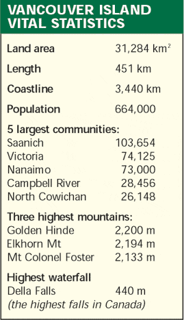
Russian, Spanish, British, French and American ships began visiting the region in the 18th century, but it was the visit of Capt James COOK to NOOTKA SOUND in 1778 that led to the beginning of the trade in SEA OTTER skins that attracted many commercial vessels to the coast (see FUR TRADE, MARITIME). In 1789 the Spanish established a base at Nootka and the ensuing NOOTKA SOUND CONTROVERSY almost led to a European war. Permanent European settlement of the Island did not begin until 1843, when James DOUGLAS began construction of FORT VICTORIA for the HBC. The European population grew slowly, though the discovery of rich coal fields at NANAIMO sparked the development of a mining industry (see COAL MINING, VANCOUVER ISLAND). The Island became a Crown colony in 1849 (see VANCOUVER ISLAND, COLONY OF) and entered union with the mainland in 1866, but the provincial capital at VICTORIA was soon eclipsed as an economic power by Vancouver, which took advantage of its location as the Pacific terminus of 3 transcontinental railways. On the Island, settlement concentrated around Victoria, at the coal-mining centres of LADYSMITH, Nanaimo and CUMBERLAND, and in the rich farming regions of the SAANICH PENINSULA and COWICHAN and COMOX valleys (see AGRICULTURE). RAILWAY and truck LOGGING exploited the FOREST resource and with the opening of BC's first paper mill on the Alberni Inlet in 1891, the PULP AND PAPER industry soon followed, making the FOREST INDUSTRY the Island's largest employer. The harbour at ESQUIMALT was headquarters for Britain's naval fleet in the Pacific from 1865 and for Canada's Pacific fleet since 1910. Greater Victoria, with over half the Island population, has communicated with its hinterland via the ESQUIMALT & NANAIMO RWY, completed to COURTENAY in 1914. Construction on a new $1.2 billion highway down the rapidly urbanizing east coast began in 1993. Since 1980 the Island's growth has been largely as a TOURISM and retirement destination, a trend that solidified in the late 1990s with the decline in both the COMMERCIAL FISHING and coastal logging industries. See map, and chart showing Vancouver Island's vital statistics.
by Stephen Hume
Reading: Kim Goldberg, Where to See Wildlife on Vancouver Island, 1997; Lindsay Elms, Beyond Nootka: A Historical Perspective of Vancouver Island Mountains, 1997; Charles Lillard, Seven Shillings a Year: The History of Vancouver Island, 1986; George Nicholson, Vancouver Island's West Coast, 1762–1962, 1965; Ian Smith, The Unknown Island, 1973; Rolf Ludvigsen and Graham Beard, West Coast Fossils: A Guide to the Ancient Life of Vancouver Island, 1997.
-
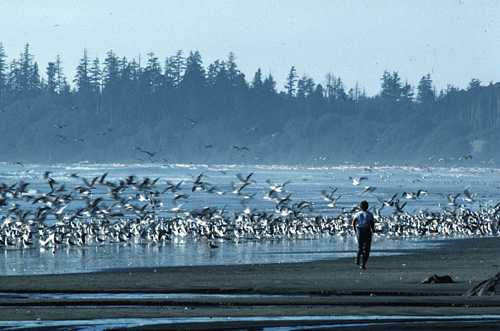
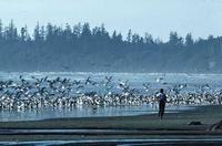 Long Beach, a spectacular stretch along the west coast of Vancouver Island. Roy Luckow photo
 -
Charts and graphs
-
Internet links