- EBC Home
- Subjects
- Index
- About the EBC
- Using the EBC
- Maps
- Feature Articles
- Videos
- BC Facts
- For Teachers
- French Language Resources
- Books about BC
- BC Links
![]()
![]()
Roads and Highways
ROADS AND HIGHWAYS have been an important part of the economic infrastructure in BC since the mid-1850s, when the first wagon road was built, linking FORT VICTORIA to CRAIGFLOWER farm at the head of ESQUIMALT Harbour.
Earliest Roads
In 1862 a TRAIL, later widened for wagons, was driven north across the MALAHAT to the COWICHAN Valley. On the mainland, road building commenced with the discovery of GOLD on the FRASER R. The first route to the Interior was the DOUGLAS TRAIL between HARRISON LK and LILLOOET, built in 1858. Later the CARIBOO WAGON ROAD was completed from YALE to BARKERVILLE in 1862–65.
BC's rugged terrain made road construction difficult; a network of major roads evolved slowly. From 1858 to 1908, bridge and highway construction was the responsibility of the chief commissioner of lands and works. It was an ideal job from which to control development and dispense patronage, and several PREMIERS kept it for themselves. The Cariboo Wagon Road was built with the help of the ROYAL ENGINEERS, but once they withdrew from the colony private contractors took over, entrepreneurs such as Joseph TRUTCH, Thomas SPENCE, Gustavus WRIGHT and Alfred WADDINGTON. Waddington's attempt to push a road across the CHILCOTIN from BUTE INLET touched off the CHILCOTIN WAR in 1864. After BC joined CONFEDERATION in 1871, road construction consumed about 45% of the province's budget. Much of the pick-and-shovel work was carried out by rural settlers labouring for 50 cents to $1 a day.
Close to 9,000 km of roadway criss-crossed the FRASER VALLEY, the KOOTENAY and the central Interior by 1900, and snaked up the east coast of VANCOUVER ISLAND from VICTORIA, but they were little better than dirt tracks. Flooding, LANDSLIDES, snow and other blockages rendered them impassable for long periods of time and little effort was expended maintaining them. For example, the road from Yale to SPENCES BRIDGE was closed from 1891 to 1927, disrupting the road connection between the coast and the Interior.
Road-building, 1908 to the 1950s
Political scandals led Premier Richard McBRIDE to put highways and bridges under a new department of public works in 1908. The first minister was Thomas "Good Roads" Taylor, who doubled the amount of roadway over the next 6 years. The speed limit at the time was 24 km/h, and while some urban streets were "macadamized," asphalt paving was not introduced until 1910, when Columbia Bitulithic Ltd, the dominant paving company in the province for the rest of the century, was formed.
Construction on a large scale continued in the 1920s, stimulated by the growing popularity of the automobile. The coast was finally connected to the Interior by a new highway up the Fraser Canyon in 1927, though it was not until 1940 that the last link in the trans-provincial highway, known as the BIG BEND HWY, was built between GOLDEN and REVELSTOKE. A significant road-building and general contracting firm that emerged during this period was Dawson Wade Construction Co, founded in 1922 by Fred J. Dawson and Henry Wade. Highway construction slowed during the hard times of the Depression, despite large-scale projects such as the Pattullo Bridge (1937) and LIONS GATE BRIDGE (1938), while during WWII the most important development was the ALASKA HWY, built by the American military.
Some enduring names in BC road construction emerged after WWII as the government tried to make the province accessible to the growing number of people with automobiles. Emil Anderson Contracting Co Ltd began in HOPE in 1946. Its first major contract was the HOPE–PRINCETON HWY, completed in 1949, and subsequently it was involved in many major highway projects. The companies that later merged as JJM Group also date from the 1940s. By 1950 only 10% of BC highways were paved. In response, new paving and aggregate suppliers entered the market; notably the BA Blacktop Group with headquarters in N VANCOUVER.
Road-building under the Socreds
There were 237,000 motor vehicles in BC by 1952, when the election of a SOCIAL CREDIT government ushered in a period of rapid highway construction and improvement. Led by Phil GAGLARDI, minister responsible for highways from 1952 to 1968, the Socreds used road construction as a means of stimulating economic development and a tool of political patronage. By 1966 the province was spending $100 million a year on highways, almost triple what the entire provincial budget had been at the end of the war. Major projects included the George Massey Tunnel, a 4-lane freeway to the US border and another to Hope, 7 Fraser Canyon tunnels, the PORT MANN and Second Narrows (see IRONWORKERS MEMORIAL) bridges, the TSAWWASSEN ferry (see BC FERRY CORP) causeway and kilometre after kilometre of fresh asphalt. A major new highway project came during the 1980s when the government of Bill BENNETT pushed through the COQUIHALLA HWY against much opposition. In 1988 the Social Credit government of Bill VANDER ZALM privatized highway and bridge maintenance, making BC the first state or provincial government in N America to get out of the business of looking after its roads. In response, most large contractors set up road maintenance divisions in their companies. Several new firms were created at the same time, 2 of the larger ones being Mainroad Contracting Ltd in SURREY and Emcon Services Ltd in MERRITT. The BC Road Builders and Heavy Construction Assoc, established in 1966 with 12 member companies, has grown to 180 members. In 1993 the NDP government established the BC Transportation Financing Authority to look after transportation infrastructure, including highways. By the year 2000 there were 23,710 km of paved highway and 18,730 km of unpaved road in BC available to the 2.3 million motor vehicles in the province.
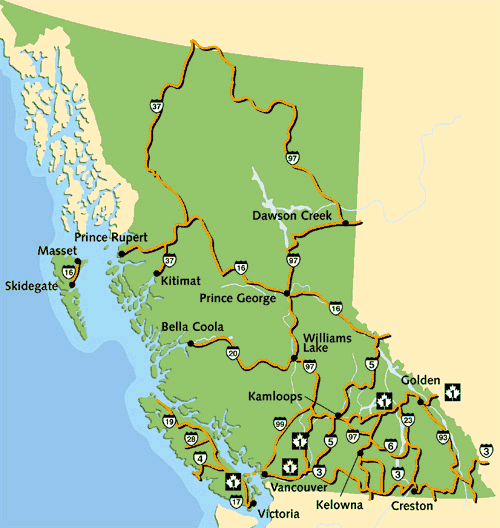
Major Highways on Vancouver Island
#1, the TRANS-CANADA HWY, begins at Mile 0 at BEACON HILL PARK in Victoria, runs north 113 km to NANAIMO, then crosses by ferry to HORSESHOE BAY on the mainland, goes through VANCOUVER and heads east through the Fraser Valley, following more or less the route of the CPR across BC. Portions of the Vancouver Island section of Hwy #1 were upgraded during the 1990s as part of the Island Highway rebuilding project, the largest construction job in the Island's history.
#17 is the Patricia Bay Hwy, a 32-km stretch connecting Victoria to the ferry terminal at Swartz Bay.
#19 is the northern portion of the Island Hwy from Nanaimo 391 km to PORT HARDY. The section from Nanaimo to CAMPBELL RIVER has been upgraded as part of the Island Hwy rebuilding project. The northern section as far as the top of the Island was only completed in 1979.
#4 runs 140 km across the Island from PARKSVILLE through PORT ALBERNI to PACIFIC RIM NATIONAL PARK and connects UCLUELET and TOFINO on the west coast. The western section was not paved until the early 1970s.
#28 runs 92 km across the middle of the Island from Campbell River to GOLD RIVER.
Major Highways on the Mainland
#3, known also as the Crowsnest Hwy, is the principal route across the southern part of the province just above the US border. It begins at Hope and the 136-km section to PRINCETON through MANNING PROVINCIAL PARK, completed in 1949, is called the Hope–Princeton Hwy. Where #3 crosses Kootenay Pass (el 1,774) between SALMO and CRESTON, it is the highest paved road in BC.
#5 is the Coquihalla Hwy running from Hope 210 km northeast to KAMLOOPS. Completed in 1987, it is BC's only toll highway. North of Kamloops #5 continues 340 km to TÊTE JAUNE CACHE, a section of road known as the Yellowhead South.
#16 is the Yellowhead Hwy stretching from YELLOWHEAD PASS in the ROCKY MTS westward across the province to PRINCE RUPERT via PRINCE GEORGE. It also continues by ferry across HECATE STRAIT to the QUEEN CHARLOTTE ISLANDS where it links MASSET and SKIDEGATE.
#20 is the Chilcotin Road, the third route to the coast, connecting WILLIAMS LAKE 456 km across the Chilcotin Plateau and through the COAST MTS to BELLA COOLA.
#37 is the Stewart-Cassiar Hwy running north 721 km from the GITWANGAK at the SKEENA R east of TERRACE to Watson Lake in the Yukon, where it joins the Alaska Hwy. A section of the Stewart-Cassiar heads west at MEZIADIN LAKE Junction to STEWART. The northern section was not completed until the early 1970s and put an end to scheduled riverboat travel on the lower STIKINE R.
#93 begins at the ROOSVILLE border crossing south of FERNIE and follows the ROCKY MT TRENCH north before crossing the mountains via KOOTENAY NATIONAL PARK and Vermilion Pass (el 1,651 m) to Banff, AB. It connects to highways in the US leading to Seattle, and before 1927 it was the only route from Alberta to the Pacific Ocean.
#97 is the only highway running north–south the length of BC. It begins at the US border near OSOYOOS and travels north through the OKANAGAN VALLEY, then west to Kamloops. At CACHE CREEK it turns north again and is called the Cariboo Hwy; it continues 441 km to Prince George, much of this distance following the old Cariboo Wagon Road. From Prince George north to DAWSON CREEK and the PEACE R country it is called the HART HWY, after Premier John HART. From Dawson Creek, #97 becomes the Alaska Hwy as it winds its way 2,400 km to Fairbanks.
#99 runs north–south, connecting Vancouver to the US border at Blaine, Wash. To the north it heads up HOWE SOUND, where it is known as the SEA TO SKY HWY, then via WHISTLER and PEMBERTON over the Duffey Lake Road to Lillooet on the Fraser R. It offers an alternative route to the Interior from the Trans-Canada. The portion between Vancouver and Whistler was upgraded in anticipation of the 2010 Olympic Games.
-
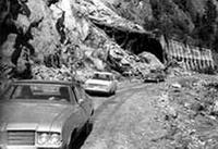 Cavalcade organized in 1972 to prove that the Coquihalla was a feasible route for a highway. Bob Egby/Vancouver Province
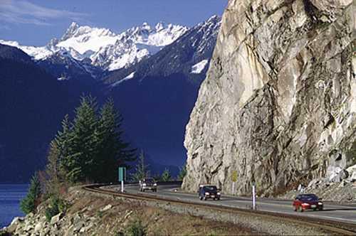
 Sea to Sky Hwy (Hwy 99) at Porteau Cove. Keith Thirkell photo
 -
Maps
-
Internet links
