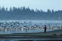
Vancouver Island
VANCOUVER ISLAND, 31,284 sq km, is Canada's tenth-largest island and the largest on the Pacific Coast of N America.
Physical Geography
The exposed top of a submerged mountain system, it lies parallel to the continent on a northeast–southeast axis, extending 460 km from JUAN DE FUCA STRAIT to Queen Charlotte Strait. JOHNSTONE STRAIT in the north and GEORGIA STRAIT in the south separate it from the BC mainland. A rugged spine of mountains rises to altitudes in excess of 2,000 m,...
If you are already registered on KnowBC, login now to get access to the full article.
You may already have access to KnowBC through your school, university or library.
- Schools that subscribe to KnowBC
- Colleges and universities that subscribe to KnowBC
- Public libraries that subscribe to KnowBC
If you do not already have access to KnowBC, you can subscribe.
-
Charts and graphs
-
Internet links
Copyright 2001-2025 Harbour Publishing

