- EBC Home
- Subjects
- Index
- About the EBC
- Using the EBC
- Maps
- Feature Articles
- Videos
- BC Facts
- For Teachers
- French Language Resources
- Books about BC
- BC Links
![]()
![]()
Columbia River
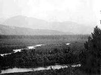
COLUMBIA RIVER, 2,000 km (763 km in BC), originates in Columbia Lk in the southern ROCKY MT TRENCH. After flowing north along the floor of the trench past GOLDEN, it enters KINBASKET LK, a reservoir created in the 1970s when the river was flooded and the MICA DAM was constructed. The reservoir drowned what was formerly known as the Big Bend of the Columbia, where it made an abrupt U-turn around the north end of the SELKIRK MTS and began to flow south. This route was followed by the BIG BEND HWY, which opened in 1940 and provided the shortest ROAD connection through the Interior until it was replaced by the ROGERS PASS section of the TRANS-CANADA HWY in 1962. Since construction of the dam, the river flows south out of Kinbasket through a series of long, narrow reservoirs: Lk Revelstoke and the ARROW LKS. Near CASTLEGAR it is joined by the KOOTENAY R, its major tributary, and continues its southward flow past TRAIL to cross the US–Canada border at WANETA. In the US it winds south through Washington state, then veers west, forming the border with Oregon until it reaches the Pacific Ocean at Astoria. The Columbia drains a total area of 155,000 sq km, of which 102,800 sq km are in BC. Named by Capt Robert GRAY, who sailed his ship Columbia Rediviva into the mouth of the river in 1792, it is the largest N American river by volume flowing into the Pacific Ocean and the third longest river in N America after the Mississippi and the Mackenzie. The upper reaches of the river were located by the FUR TRADER and explorer David THOMPSON in 1807. In 1811 he travelled by CANOE down the river to the Pacific, hoping to establish a fur trade post for the NORTH WEST CO at its mouth. He arrived to find American traders already installed in Fort Astoria. He returned east and followed the river all the way to its headwaters, the first person known to have travelled its length. Later the river was used by the HBC as a link in the main fur trade transport route connecting the BC Interior with the Pacific (see also FUR BRIGADES; NEW CALEDONIA). Until 1846 the Columbia was the southern BOUNDARY of British territory in the Pacific Northwest. With the signing of the OREGON TREATY, the British withdrew north of the 49th parallel of latitude and the southern Columbia was absorbed into the US.
The Columbia is one of the world's greatest sources of HYDROELECTRIC power. The Americans began development in the 1930s with the construction of the Grand Coulee and Bonneville dams. Eventually 11 dams were built on the American side of the border and another 3 dams in BC—the DUNCAN, KEENLEYSIDE and Mica dams—as part of the COLUMBIA R TREATY (1964). Along with the production of electricity, the dams were used for flood control and irrigation. As a result of the development, SALMON stocks in the river, once plentiful, were drastically reduced when land and communities in BC were flooded to create reservoirs. In 1995 the COLUMBIA BASIN TRUST was established to bring some of the revenue from sales of hydroelectric power on the Columbia R back into the W KOOTENAY. See also RIVERS.