- EBC Home
- Subjects
- Index
- About the EBC
- Using the EBC
- Maps
- Feature Articles
- Videos
- BC Facts
- For Teachers
- French Language Resources
- Books about BC
- BC Links
![]()
![]()
Fraser River
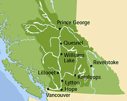
FRASER RIVER, at 1,399 km the longest river wholly within BC, rises in the ROCKY MTS at Fraser Pass about 40 km southwest of Jasper. It flows north to the vicinity of Yellowhead Lk and west via Moose Lk toward Mt ROBSON before entering the ROCKY MOUNTAIN TRENCH. It follows the Trench to the northwest before sweeping in an arc to the southwest toward PRINCE GEORGE, where it turns south and continues through the centre of the province; it takes a right turn at HOPE, then heads west to empty into the GEORGIA STRAIT at VANCOUVER. The Fraser drains an area of 231,510 sq km, about a quarter of BC. Nearly 65% of the provincial population lives in its basin, most between Hope and Vancouver. The basin produces an estimated two-thirds of BC's income. Many different FIRST NATIONS have lived along its banks, attracted by the plentiful runs of migrating SALMON.
The Fraser was descended by Simon FRASER, after whom it is named, in 1808 (see also FUR TRADE, LAND-BASED; NORTH WEST CO). He reported the canyon section between Hope and LILLOOET as being virtually impassable, so it was never used as a fur trade route to the Interior. The discovery of gold on the sandbars of the canyon in 1857 attracted the first influx of outsiders to the mainland (see GOLD RUSH, FRASER R). The CARIBOO WAGON ROAD was constructed between 1862 and 1864 and the river has been a major road and rail corridor connecting the coast to the Interior ever since.
The Fraser supports 5 species of salmon, some of which migrate over 1,300 km from the sea to their spawning grounds, and accounts for 60% of the annual provincial salmon catch. During construction of the CPR in 1913–14, rock slides in HELLS GATE blocked the salmon runs and caused serious depletion of all upriver salmon stocks. Not until 1941 did the US and Canada provide funds to alleviate the damage; in 1946 the first salmon ladders were completed to allow migrating salmon to get around the obstruction.
The river basin contains 48% of BC's farmland, most of it in the broad, fertile valley between CHILLIWACK and the coast. The main stem of the Fraser has never been dammed, though there has been extensive diking and industrial development. Over the years the river has been polluted by agricultural and industrial waste and poorly treated sewage; by the mid-1990s it was among the 10 most endangered rivers in BC. The flow of water has been reduced over the years by dam construction on its tributaries, and the temperature of the river has risen, threatening fish stocks. The biggest polluters are Greater Vancouver's sewage treatment plants, which discharge more than 2 million cubic m of waste into the river every day. Many efforts have been made to clean up the river, but rapid population growth along its banks, especially in the Lower Mainland, has made the situation worse.
The lower river is susceptible to heavy spring flooding resulting from rapid snowmelt in the watershed. The worst flooding on record occurred in 1894, but another serious flood in 1948 caused more property damage because the valley was more populated. The Fraser system has 600 km of flood-control dikes between Chilliwack and the mouth of the river; nevertheless a 1996 report warned that communities in the lower valley and at the mouth remain in danger from serious flooding and called for several million dollars' worth of flood control projects. The Fraser has been designated as a BC HERITAGE RIVER and is one of Canada's newest Canadian heritage rivers. See also AGRICULTURE; DISASTERS; FISHING, ABORIGINAL; LAKES.
-
Video
-
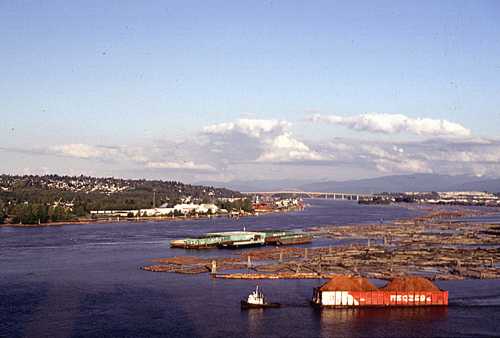
 The Fraser River, looking east from New Westminster, with a view of working vessels and the Port Mann Bridge. Rick Blacklaws photo
 The Fraser River near Clinton. Rick Blacklaws photo
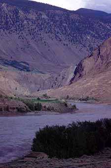
 -
Maps
-
Internet links
-
Audio