- EBC Home
- Subjects
- Index
- About the EBC
- Using the EBC
- Maps
- Feature Articles
- Videos
- BC Facts
- For Teachers
- French Language Resources
- Books about BC
- BC Links
![]()
![]()
Kootenay
KOOTENAY is the name applied to the mountainous southeast corner of BC, extending eastward from the OKANAGAN VALLEY all the way to the Alberta border and from the US border north to the TRANS-CANADA HWY. The region takes its name from the KTUNAXA (Kutenai) First Nation. It has an area of 59,500 sq km, which is 6.7% of the total land area of the province, and a population of 153,400. Unofficially the region is divided into West Kootenay, between the MONASHEE and PURCELL MTS and including the SELKIRK MTS, and East Kootenay, which is dominated by the ROCKY MT TRENCH between the Purcells and the ROCKY MTS. (Increasingly the southwest corner of the Kootenay region, between ROCK CREEK and CHRISTINA LK, is known as the BOUNDARY DISTRICT and has its own separate identity.) For purposes of government the area is subdivided into 3 REGIONAL DISTRICTS: East Kootenay, Central Kootenay and Kootenay–Boundary.
The rugged topography features a series of roughly north–south mountain ranges separated by deep valleys and long, narrow LAKES. The two main rivers are the COLUMBIA and the KOOTENAY; both have major dams that have created large reservoirs, including KOOTENAY, Upper and Lower ARROW, SLOCAN, KOOCANUSA and Duncan (see DUNCAN DAM) lakes. CRANBROOK (pop 18,476) and NELSON (9,298) are the largest cities. The region was occupied by the SINIXT and the Ktunaxa peoples when traders arrived early in the 19th century. First explored by David THOMPSON, it did not play a major role in the fur trade, so it was not until a MINING boom erupted later in the century that outsiders arrived in any number. GOLD was discovered on WILD HORSE CRK near Cranbrook in 1864, followed by major COPPER, lead–ZINC, gold, COAL and SILVER discoveries at different locations in the 1880s and 1890s. A network of small towns sprang into existence to service the mines. PADDLEWHEEL STEAMBOATS appeared on the larger lakes and a flurry of railway building, culminating with the arrival of the CPR's CROWSNEST PASS line in 1898, linked the region to outside markets. The hardrock mining boom collapsed by the 1920s—though the SULLIVAN MINE at KIMBERLEY, owned by COMINCO, remained productive—and the regional population decreased from a high of 18% of the provincial total in 1900 to 4% by 1996. With the decline of mining, the FOREST INDUSTRY became the most important employer in the region and has continued to be the economic mainstay of many communities. Coal mining re-emerged in the late 1960s as a significant factor in the regional economy. Coal from mines in the ELK R valley is sent by rail to ROBERTS BANK and exported principally to Japan. The mountainous topography has confined AGRICULTURE to a few locations, mainly around CRESTON and in the Rocky Mt Trench. Though HYDROELECTRIC power has been generated on the Kootenay R since 1898 (see WEST KOOTENAY POWER & LIGHT CO), the region was affected profoundly by the COLUMBIA RIVER TREATY and subsequent dam construction in the 1960s. The Hugh KEENLEYSIDE DAM at CASTLEGAR raised the level of the Arrow Lks in 1969, drowning several small communities in the process. The COLUMBIA BASIN TRUST was formed in 1995 to ensure that the benefits of hydroelectric development are fed back into the region.
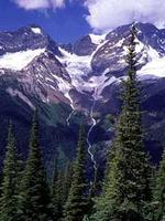
Along with a rich endowment of natural resources, the Kootenay is blessed with a dramatic natural landscape that attracts a growing number of visitors for hiking, camping, fishing and SKIING in the winter (see TOURISM). Along with KOOTENAY and YOHO NATIONAL PARKS, there are several major PROVINCIAL PARKS, including VALHALLA, KOKANEE GLACIER, TOP OF THE WORLD, Height of the Rockies, MT ASSINIBOINE, Gladstone, Granby, Goat Range, AKAMINA–Kishenina and PURCELL WILDERNESS CONSERVANCY. The BURGESS SHALE area in Yoho National Park is a UNESCO WORLD HERITAGE SITE. The Kootenay is also known for its thriving artistic community composed of writers, visual artists and artisans who appreciate the region's beauty and relative isolation and contribute to its distinctive character.