- EBC Home
- Subjects
- Index
- About the EBC
- Using the EBC
- Maps
- Feature Articles
- Videos
- BC Facts
- For Teachers
- French Language Resources
- Books about BC
- BC Links
![]()
![]()
Okanagan Valley
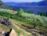
OKANAGAN VALLEY is a broad U-shaped trough in south-central BC occupied by a chain of lakes that drain south via the Okanagan R to Osoyoos Lk. The lakes, including Swan, OKANAGAN, KALAMALKA, Wood, Duck, SKAHA, VASEUX and Osoyoos, are remnants of a glacial sea—Penticton Lake—that inundated the area some 10,000 years ago (see GLACIATION); the largest is Okanagan Lk. Alluvial deposits left behind when the glaciers retreated are the basis of the valley's bountiful agricultural production today. It is bounded on the east by the MONASHEE MTS and on the west by the Thompson–Okanagan Plateau, and it extends about 160 km from VERNON to the US border.
Comprising roughly 3% of the total area of BC, the Okanagan Valley contained about 8% of the provincial population (300,000 people) in 1997, making it the most densely populated region in the Interior. Half a million people were expected to live there by 2021. Most of the population is centred in the 3 largest communities: PENTICTON, KELOWNA and Vernon; each is the economic and administrative focus of its own region. Lying as it does in the rainshadow of the mountains, the valley is sunny and dry, especially south of Penticton. Temperatures are hot in summer and usually mild in winter. The valley is a unique ecosystem that hosts more than 30% of BC's ENDANGERED SPECIES of wildlife as well as 100 rare or endangered PLANTS. Since the 1950s, water-control dams have reduced flooding on the Okanagan R and around Osoyoos Lk.
The valley is the traditional territory of the OKANAGAN First Nation, who occupy several communities. The first outsider known to have visited the area was a fur trader, David Stuart, who in 1811 travelled up the lake on a scouting expedition for the PACIFIC FUR CO. Until 1847, fur traders used the valley to supply Interior posts and carry furs down to the coast (see FUR TRADE, LAND-BASED; FUR BRIGADES). A few settlers arrived with the 1858–62 GOLD RUSH, principally to raise cattle and other livestock for the miners. Ranching remained the dominant activity until the end of the 19th century, when the first irrigation projects were undertaken and orchards were planted (see CATTLE INDUSTRY; AGRICULTURE; TREE FRUITS). During the 1920s and 1930s, fruit growing was established as the valley's main economic activity; at the close of the 20th century the valley was second only to the lower FRASER VALLEY as a source of agricultural products. Since the 1930s, grape growing has expanded dramatically, supplying a WINE MAKING INDUSTRY that in Canada is second in importance only to the Niagara Peninsula.
In 1892 the SHUSWAP & OKANAGAN RWY began operations between OKANAGAN LANDING and SICAMOUS, linking the valley to the outside world via the CPR main line. The CPR then launched PADDLEWHEEL STEAMBOAT service on Okanagan Lk, which lasted until 1937. The south end of the valley got its own rail connection in 1915 with the completion of the KETTLE VALLEY RWY. ROADS AND HWYS eventually replaced rail as the most important transportation link. Since the completion of the COQUIHALLA Connector (Hwy 97C) in 1990, the valley is only about 4 hours from VANCOUVER by car. AIRPORTS are located at Kelowna and Penticton. Along with agriculture, DAIRY FARMING and LOGGING are also economically important, particularly in the north end of the valley. Since the 1960s, TOURISM has become important in both summer and winter. Along with a variety of water-related activities, there are three major ski resorts: Apex Alpine near Penticton, Big White at Kelowna and Silver Star outside Vernon (see SKIING). The valley attracts a growing number of retirees, who appreciate its pleasant climate and scenic beauty; during the 1990s a national magazine picked Penticton and Kelowna as 2 of the top 10 places in Canada to live. However, many people fear that residential and tourist development is threatening farmland and destroying the valley's unique plant and animal life. The Okanagan GRASSLANDS, for example, are considered one of the 4 most endangered ecosystems in Canada.