- EBC Home
- Subjects
- Index
- About the EBC
- Using the EBC
- Maps
- Feature Articles
- Videos
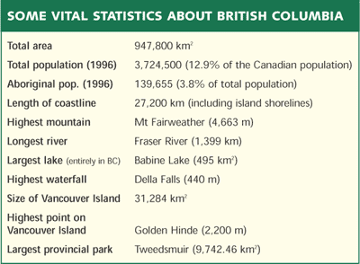
- BC Facts
- For Teachers
- French Language Resources
- Books about BC
- BC Links
![]()
![]()
Physical Geography of BC
British Columbia is a mosaic of diverse landscapes, ranging from the icefields of the COAST MTS to the pocket deserts of the OKANAGAN VALLEY and the boggy plains of the LIARD R. Although the "SuperNatural" scenery of the province attracts the attention of TOURISTS and residents alike, few people are aware of the manner in which the MOUNTAINS and lowlands, RIVERS, LAKES and COASTLINE have been sculpted by natural forces.
Evolution of the Landscape
The character of a landscape depends upon both the landforms that are present and the earth materials that comprise the landforms. "Landform" refers to the shape of the land surface: valleys, steep slopes and river terraces are examples of landforms. "Earth materials" are the bedrock and younger sediments, or soils, that immediately underlie the land surface; examples are granite, sandstone, beach sand and river gravels. Thus, this account begins with geological history (or origin of the rocks), and continues with a description of how the bedrock was sculpted into its present configuration and how the younger sediments were deposited.
Plate Tectonics and Development of Major Physiographic Regions
About 200 million years ago the part of the globe that is now BC was mostly an empty ocean. To the east, the primeval continent of Pangaea was beginning to disintegrate and the large fragment that would eventually form the ancient crystalline core of N America began to drift slowly westward. Sediments of both marine and terrestrial origin had been accumulating along the western edge of Pangaea for many millions of years. The ocean floor had gradually subsided under the weight of these deposits, resulting in the formation of a deep trough full of fossiliferous muds and oozes interlayered with sand, silt and clay. Sedimentation and subsidence continued along the leading edge of the new continent until the sediments were several thousand metres thick.
The ancient Pacific, toward which our continent was drifting, contained several smaller land masses of volcanic origin, similar perhaps to the present-day Hawaiian Islands. These islands and the adjacent shallow seas consisted of coral reefs, lagoons, beaches, deltas and marine sediments, as well as lava rocks and detrital volcanic material such as cinders and ash.
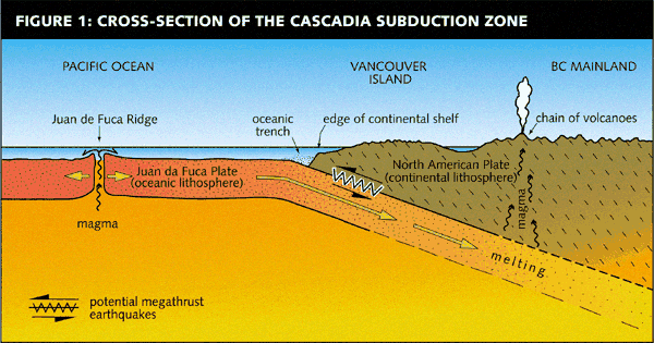
The theory of plate tectonics envisages that the outermost layer of the earth (the crust and upper mantle), the "lithosphere" (solid or rock layer), is subdivided into rigid "plates" that move independently. Where plates are pulling apart, new lithosphere is created by vulcanism. Where plates are converging, one rides up and over the other and pushes the lower plate down (subducts) toward the earth's interior, where it is eventually melted and consumed. A plate boundary of this type, known as a "subduction zone," has formed the western edge of the N American Plate for the past 200 million years (Fig 1). In effect, the continent has been riding westward over the floor of the Pacific Ocean, inexorably shortening the distance between itself and the volcanic islands of the Pacific.
Several collisions between the oceanic land masses and the continent occurred between about 100 and 50 million years ago. Because the islands consisted of lightweight, relatively buoyant rock, they were not drawn down into the subduction zone and consumed. Instead, they remained at the earth's surface and became attached to the leading edge of the continent. As each new land mass (referred to by geologists as a "terrane") was accreted (collided with and became stuck to the edge of the continental plate), the subduction zone migrated to the new western edge of the continent. During the earliest collisions, the sediments of the previously offshore trough were trapped between the converging land masses, squeezed upward and thrust eastward until they rested on top of the western edge of the original continent. Immense pressure and extremely high temperatures were generated during the accretion of terranes and during the upthrusting of the sedimentary trough. These resulted in the melting of some rocks and the metamorphosis (alteration by extreme heat, extreme pressure, or both) of others. Both intrusion of magma (molten rock) and metamorphism were widespread along the boundaries of major terranes, and the trough sediments were compressed and recrystallized.
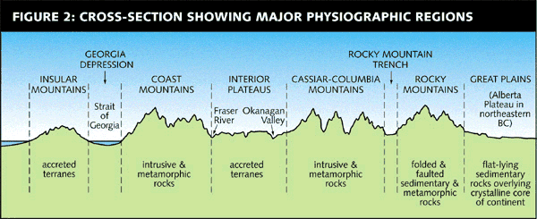
Large parts of the western CORDILLERA of N America, as well as BC, were formed as a result of these tectonic processes. The Cordillera flanks the ancient crystalline core of the continent, which is exposed in the Canadian Shield and underlies most of the Great Plains, including the Canadian prairies and Mackenzie R basin. In BC the ancient core underlies the relatively flat lands of the PEACE R–FORT NELSON area; the upthrust sedimentary rocks comprise the ROCKY MTS. The remainder of the province consists of 2 major groups of terranes, now the Interior Plateaus and the Insular Mountains (VANCOUVER ISLAND and the QUEEN CHARLOTTE ISLANDS), and two mountain belts, now the Coast Mts and the Cassiar-COLUMBIA MTS. Both mountain belts are characterized by the intrusive rocks (formerly magmas) that predominate in the boundary zones between terranes and between the most easterly terrane and the Rocky Mts (Fig 2). This complex history accounts for the great geological diversity of BC.
Faults and Earthquakes
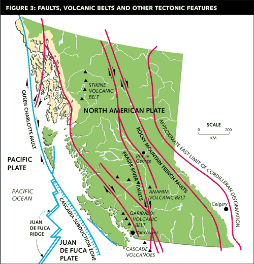
The final phases in the geological development of BC occurred after the accretion of terranes. Fig 3 shows the familiar northwest–southeast trend of the main physical features of the province.
This is partially the result of relatively recent faulting along ruptures that trend parallel to the western edge of the continent. These developed because while the eastern margin of the Pacific Plate was being overridden by the western margin of the N American Plate, it was also moving northwestward; that is, the Pacific Plate was (and still is) rotating in a counter-clockwise direction. This movement caused slivers of the adjacent continent to be dragged northwestward, generating several major shear zones (transverse faults) where the western side of the fault has moved northwestward relative to the eastern side. The ROCKY MT TRENCH is one such fault zone, and the FRASER R Canyon between HOPE and LILLOOET (the boundary between the Coast and CASCADE MTS) is another (Figs 2 and 3).
No evidence has been found for geologically recent movement along the major transverse faults in eastern and central BC. However, some of the western faults are still active, giving rise to EARTHQUAKES. Tremors are relatively frequent along the Queen Charlotte Fault (Fig 3), which is the present-day boundary between the N American Plate and the Pacific Plate. The St Elias Fault is also active. To the south of the Queen Charlotte Fault, the western boundary of the N American Plate coincides roughly with the edge of the continental shelf off the west coast of Vancouver Island. This boundary is the surface expression of the Cascadia Subduction Zone that plunges down beneath Vancouver Island. Geophysical investigations indicate that this subduction zone is active, although differential movement of the 2 plates that rest against each other here has not been directly recorded. It is thought that a sudden rupture here could cause a great (megathrust) earthquake (Fig 1). Most small and moderate historical earthquakes in southwestern BC have resulted from movements within the N American and Juan de Fuca Plates.
Landform History
The geological history described above formed the framework of BC, as illustrated by the broad relations between tectonic features and the major physiographic regions shown in Fig 2. However, present-day landforms are the products of more recent earth history. In general, the largest landforms, such as plateaus and mountain ranges, have developed since about 50 million years ago (the mid-Tertiary Period); moderately sized landforms, such as coastal FJORDS, date from the GLACIATIONS of the Quaternary Period (2 million to about 12,000 years ago); smaller features, such as river terraces and canyons, have formed since then, during what is called post-glacial time.
Upland Surface
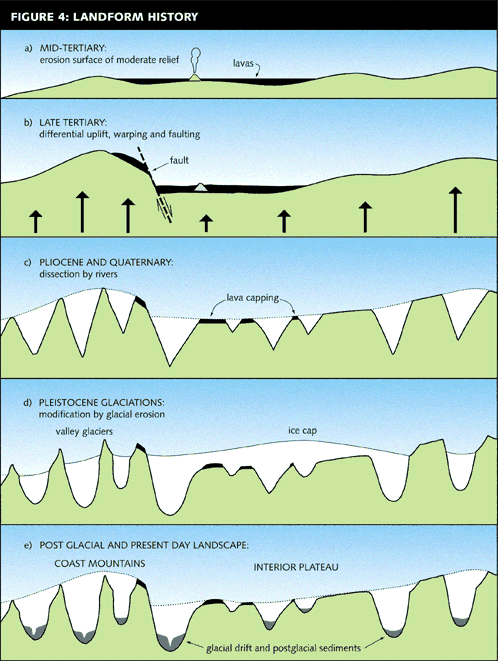
During the Tertiary Period, there were long intervals of time during which very little upheaval resulted from the movement of the tectonic plates, and the elevations of land and sea remained relatively constant. The most significant of these quiet times, which occurred during mid-Tertiary time, lasted for several million years while erosion and deposition created an erosion surface with a few hundred metres local relief across most of BC (Fig 4a). Then, during the late Tertiary, renewed tectonic action resulted in widespread rising of the land, with uplift being greatest in the belts that are now our main mountain ranges: the Insular, Coast, Cassiar-Columbia and Rocky mountains (Fig 4b). As uplift progressed, stream gradients were steepened, resulting in increased erosion. Narrow valleys and canyons were cut into the erosion surface, forming landscapes that range from dissected plateaus in areas of moderate uplift to steep-sided mountains where uplift was greatest (Figs 4b and 4c). Today, the products of the more gentle mid-Tertiary erosion are seen in the rolling surface of the Interior plateaus and in the remnants of gently sloping terrain that are found throughout all but the most rugged parts of the mountains. These scattered patches of upland surface are the oldest landforms in BC (Fig 4e).
Vulcanism
Episodes of volcanic activity have occurred sporadically during and since the attachment of the various terranes to the western edge of N America. In BC, a major volcanic interval during early Tertiary time resulted in emplacement of extensive lavas, known as the KAMLOOPS volcanics, in south-central BC.
Another long interval characterized by periodic eruptions of basaltic lava commenced in mid-Tertiary time. This type of magma is very fluid and so it spread widely, forming vast lava lakes. In some regions, most notably the Fraser Plateau, the mid-Tertiary erosion surface became deeply buried by layer upon layer of lava (Fig 4a), and major rivers were impounded and diverted by lava dams. These lava flows, known as the Plateau Basalts, now cap large areas of the Fraser Plateau (Fig 4c), and they commonly form the rimrock along the valleys that dissect the Plateau, such as those of the CHILCOTIN and Fraser rivers. Volcanic activity occurred sporadically for a long time after uplift and dissection of the Plateau. The most recent Plateau Basalts are only about one million years ago.
Tertiary vulcanism also resulted in the formation of some major volcanoes and numerous smaller features, and in many locations eruptions have continued to occur from time to time throughout the ensuing Quaternary Era. Three noteworthy groups of volcanoes have been studied by geologists: Anahim, STIKINE and GARIBALDI volcanic belts (Fig 3). The Anahim belt trends roughly eastward from BELLA COOLA to CLEARWATER, with the age of the volcanoes decreasing eastward. The 3 volcanic centres in the west Chilcotin area—the RAINBOW, ILGACHUZ and Itcha ranges—are the eroded remnants of large, complex volcanoes that were active about 10 million years ago in mid-Tertiary time. In contrast, most of the volcanoes farther east in WELLS GRAY PROVINCIAL PARK formed during the past 3 million years, and the youngest volcanic features here are only about 5,000 years old. The Stikine Volcanic Belt, a chain of volcanoes located along a series of north–south normal faults, is dominated by the massive composite (shield) volcano of MT EDZIZA. This ice-capped mountain is the product of repeated eruptions over the course of many millions of years. Post-glacial eruptions (since about 10,000 years ago) have formed extensive lava flows and small cinder cones on the flanks of the main structure. The well-known Nass (Tseax) lava flow near GITLAKDAMIKS, about 250 years old, is also part of the Stikine belt (see NISGA'A MEMORIAL LAVA BED PROVINCIAL PARK). The Garibaldi Volcanic Belt contains many well-known features, such as the BLACK TUSK, the lava flows of the CHEAKAMUS valley near BRANDYWINE FALLS and MEAGER CREEK Hot Springs. It is another north–south trending zone that extends from the upper LILLOOET R to GARIBALDI PROVINCIAL PARK and is continued to the south by the volcanoes of the Cascade Mts in Washington and Oregon. This volcanic belt is thought to be related to the Cascadia Subduction Zone (Fig 1).
On many occasions, violent volcanic eruptions have released vast plumes of volcanic ash that covered thousands of square kilometres of BC. The ash layers deposited by 3 post-glacial eruptions are well preserved in bog and lake deposits and in some places a veneer of ash rests on glacial deposits. The most widespread ash layer originated from the cataclysmic eruption of Mt Mazama (now Crater Lake) in Oregon about 7,000 years ago. Today it can be found throughout much of southern BC, where it ranges in thickness from about 1 to 10 cm; it extends northeastward into Alberta and Saskatchewan. An eruption of Mt St Helens about 3,200 years ago produced a similar, though less widespread, ash layer that extends north through Kamloops to the vicinity of Clearwater. The third and youngest ash layer, deposited about 2,400 years ago, has been traced to a small volcanic vent near Mt Meager north of PEMBERTON (although it is known as the "BRIDGE RIVER" ash because it was first found in the vicinity of that river). A narrow plume of this ash extends eastward to beyond the Rocky Mts.
Glaciation
During the past 2 million years (the Quaternary Period), most high latitude areas have experienced CLIMATE fluctuations that have given rise to alternating glacial and non-glacial episodes. Evidence from the ocean floor, where a complete record of climate change is stored in continuously accumulating sediments, suggests that there were more than 12 major glaciations. On land, each ice advance tends to erode and destroy evidence of its predecessor, so it is not surprising that in BC we have found evidence, in the form of sedimentary layers, of only 3 major glacial episodes. The sediments and landforms of the most recent cool interval (Fraser Glaciation) are well preserved, and wood and other organic material found within the glacial deposits can be radiocarbon-dated. Thus geologists have been able to carry out relatively detailed reconstruction of the timing and events of this interval. Only Fraser Glaciation is described below, but it is likely that older glaciations had a similar history.
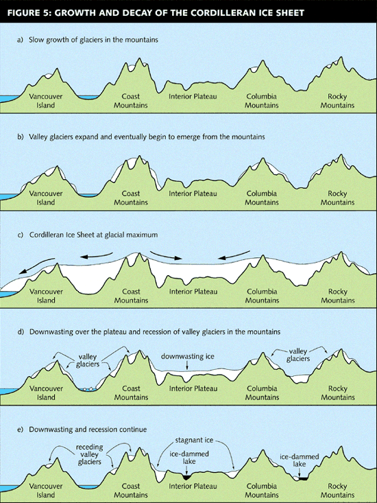
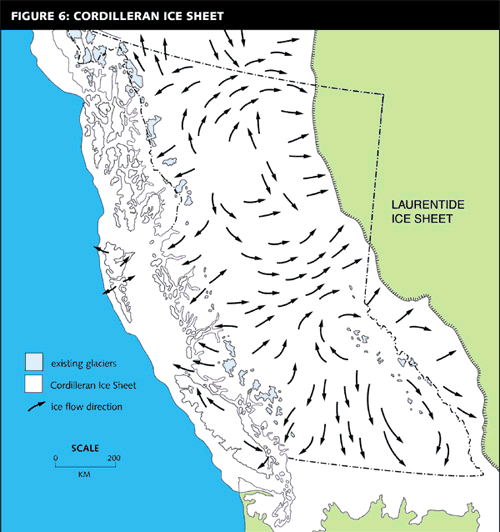
At the beginning of Fraser Glaciation, the physical landscape was probably similar to that of today, with mountains, plateaus, plains and rivers occupying their present positions (Fig 4c). About 30,000 years ago, a gradual increase in snowfall, possibly in combination with cooler summers, caused snowfields and glaciers to begin expanding in the higher parts of the mountains (Fig 5a). For about 10,000 years, as the snowline gradually descended, snow patches were transformed into small glaciers and slow glacier growth continued. Valley glaciers thickened and lengthened, and eventually emerged from the mountains and spread out onto plateaus and plains (Fig 5b). A minor glacier recession about 22,000 years ago was succeeded by renewed and more rapid glacier expansion and thickening. Eventually the ice level rose so high that all but the highest peaks in the mountains were buried and an unbroken ice sheet extended over plateaus and plains (Fig 5c). This "Cordilleran Ice Sheet" reached its maximum thickness and extent about 15,000 years ago (Figs 5d and 6). In the Interior, the ice spread onto the plateaus from accumulation zones in the high mountains to the east and west, then moved toward gaps in the surrounding mountains, such as the valleys of the Peace, Liard, SKEENA and Stikine rivers. At this time, the Cordilleran Ice Sheet resembled the present-day Greenland ice sheet, with glaciers flowing through mountains to the sea (or to the plains) from a vast central icefield.
After 15,000 years ago, relatively rapid climate amelioration caused rapid shrinking, thinning and disintegration of the Cordilleran Ice Sheet (Figs 5d and 5e). The site of VANCOUVER became ice-free about 13,000 years ago. Ice had disappeared from the southern Interior Plateau and southern valleys by about 11,000 years ago, although a short-lived re-advance occurred in the Lower FRASER VALLEY at about this time. By about 10,000 years ago, glaciers were probably no more extensive than at present. Deglaciation in some of the mountain belts appears to have been more or less the reverse of glacier advance: glacier snouts receded up-valley as the ice shrank back toward its high sources, while meltwater streams deposited outwash gravels downstream on the recently exposed valley floor. In other areas, however, particularly on plateaus and plains, large parts of the ice sheet became disconnected from the accumulation zones in the mountains by high ground that was exposed as the ice melted (Figs 5d and e). These large masses of stagnant (no longer flowing) ice melted slowly in place, gradually becoming covered by melted-out debris and leaving behind tracts of hummocky moraine, gravelly meltwater deposits, and landforms such as eskers (sinuous gravel ridges) and meltwater channels.
During deglaciation, water bodies were much more extensive than at present. Many valleys were dammed by ice, forming very long, narrow glacial lakes (Fig 5e). Fine sediments carried into these lakes by meltwater streams accumulated rapidly, reaching thicknesses ranging from less than 1 m to well over 100 m. Terraces and irregular benchlands underlain by glacial lake silts and clays are prominent features of many Interior valleys, such as the Okanagan, the South THOMPSON Valley near Kamloops, and the Fraser and NECHAKO valleys near PRINCE GEORGE. Along the coast, sea level was relatively high during deglaciation because the land had been depressed relative to the sea by the weight of the ice. On the mainland coast, sea level up to about 200 m above its present level is indicated by the elevations of raised deltas. Glacio-marine sediments, including clay, silt, and stony deposits, accumulated in areas that were inundated. The fine-grained sediments deposited in the glacial lakes and ocean are highly susceptible to erosion and LANDSLIDES, and today they cause numerous problems for engineers and planners.
Post-glacial Landscape Development
During the 10,000 to 12,000 years since the end of Fraser Glaciation, the glaciated landscape has been modified by rock weathering, gravitational slope processes, and erosion and deposition by streams, waves, and wind (Fig 4e). The results of weathering and slope movements are most apparent in the high mountains and on steep valley sides within the dissected plateaus. Steep slopes have been modified by rockfall, landslides, debris flows and snow AVALANCHES, resulting in the formation of talus slopes, debris cones and fans, and hummocky landslide debris. Terrace scarps and canyon walls alongside streams that have eroded into glacial materials are commonly unstable, especially where soils are wet and where glacial lake sediments are present.
Post-glacial landforms are also very evident along the floors of major valleys, where rivers have either eroded sideways to form broad floodplains, or cut down into glacial deposits and bedrock, forming river terraces and canyons. Similar but smaller fluvial (related to streams and rivers) landforms can be found along most tributary streams. Alluvial fans, formed where streams emerge from the mountains onto flat terrain, and river deltas are commonly the sites of modern settlement and industry because they may provide the only level or gently sloping, relatively dry land in rugged terrain. Many deltas are also sites of considerable ecological significance.
The importance of post-glacial aeolian (wind) erosion and deposition to present-day land use is far greater than its visible effects would suggest. The wind picks up small sand and silt particles from unvegetated sites, such as floodplains and steep bluffs, and re-deposits them nearby, resulting in the slow accumulation of a layer of loamy, stone-free soil. The effects of this process are most evident in the dry, sparsely treed valleys of the southern Interior, such as the Thompson, Fraser and Okanagan valleys and the Rocky Mt Trench, where the wind-deposited veneer is typically about 1 m thick. This is the basis of the relatively high agricultural capability of these lands. Without the aeolian veneer, soils derived from underlying glacial deposits or river gravels would be exceedingly stony and hard to cultivate. Sand dunes, the more familiar result of wind deposition, are not extensive in BC, but good examples of coastal dunes can be seen at LONG BEACH, and there are cliff-top dunes at FARWELL CANYON near WILLIAMS LAKE and WALHACHIN near CACHE CREEK.
Most of the BC coast is rocky and resistant to wave attack. This, combined with relatively short exposure to wave action (the shoreline has been at its present position for only about 8,000 years), explains the general rarity of landforms such as sea stacks, arches and caves when compared to the unglaciated coastlines of Washington and Oregon. Short stretches of the coast coincide with glacial deposits, which are relatively weak and susceptible to wave erosion. For example, the steep bluffs at Long Beach have been cut into glacial drift, and the sands and gravels recycled to form the beach. Extensive beaches along the east coast of Vancouver Island between NANAIMO and COURTENAY are also backed by glacial materials.
Despite the effects of weathering, slope processes, streams, wind and waves, there are large parts of BC that remain today much the same as they were immediately after they emerged from beneath the ice at the end of Fraser Glaciation. These are areas of low relief and gentle gradients, such as the upland surface of the Interior plateaus, some plains and lowlands, and some broad valley floors. The relict glacial landscape is best seen where it is not hidden by the forest cover, such as in the dry GRASSLANDS of the central and southern Interior. In such places, the casual observer can see signs of post-glacial alteration of till plains, drumlins (streamlined hills of till), eskers and meltwater channels, and even the details of the glacial landscape, such as annual moraines and tiny meltwater channels only 1–2 m high or deep. The volcanic ash layers noted above can also be identified within the soils on the upland surface in south-central BC.
The Physical Landscapes
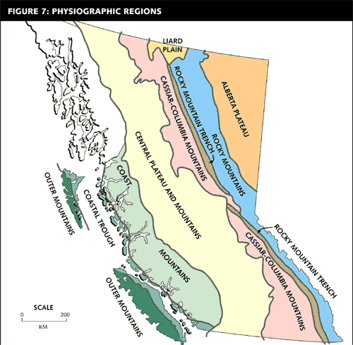
A diverse array of physical landscapes has resulted from the combined effects of geological framework and landform evolution described above. Areas of similar geology, topography and landform history, known as physiographic regions, are shown in Fig 7.
Mountain Landscapes
The spectacular scenery of the main mountain belts—the Insular, Coast, Cassiar–Columbia and Rocky mountains—is dominated by landforms of glacial erosion: horns and serrated ridges, cirques and glacial troughs with hanging tributary valleys. However, some other aspects of the landscape that derive from the characteristics of the underlying bedrock vary from one mountain region to another. For example, the prominent layering in the sedimentary and meta-sedimentary rocks of the Rocky Mts creates visual details that are quite dissimilar to the more massive, intrusive rocks of the Coast Mts. Some of these sedimentary rocks are also much more susceptible to weathering and disintegration than intrusive rocks, and so slopes covered with rocky debris tend to be relatively extensive in the Rockies.
Present-day snowline rises gradually eastward across the province, and glaciers are part of the mountain landscapes where substantial areas lie above an elevation limit that rises from about 1,700 m on Vancouver Island to about 2,600 m in the Rockies. Glaciers were larger than they are at present during the Little Ice Age of the 17th and 18th centuries, and sparsely vegetated end moraines and outwash plains mark their former extent and recent recession.
Historically the mountain belts have hindered east–west transportation and travel across BC. Even today the influence of the topography is still very evident from a brief glance at the provincial road map, where, for example, the road distance from Vancouver to TRAIL is 628 km as compared to a straight flight path of 400 km. Even where low-elevation passes were utilized, road and rail construction encountered extreme difficulties on steep and unstable slopes, and temporary blockages due to landslides, floods and snow avalanches can still have considerable economic and social impacts. Within the mountains, tens of thousands of kilometres of gravel roads have been constructed to provide access for the LOGGING and MINING industries, and more recently for recreation and tourism. The cost of constructing and maintaining these ROADS is high, as are the costs of identifying and avoiding adverse environmental effects related both to roads and other industrial activities. Attractive mountain scenery of soaring peaks and snowfields is one of the main provincial assets that has allowed development of a significant tourist industry. Backcountry travel attracts both visitors and local residents. As the number of people in the mountains grows, the hazards posed by natural processes, such as debris flows and floods, are of increasing concern. The greatest danger comes from snow avalanches, which are taking a growing toll of human lives.
Plateau Landscapes
The broad belt of Interior plateaus that extends from the Yukon to the 49th parallel (and beyond) includes level to gently sloping uplands that have undergone various degrees of dissection. For example, broad areas of upland surface in the Chilcotin (western) part of the Fraser Plateau are uninterrupted by deep valleys. By way of contrast, the Thompson Plateau has been segmented by the deep valleys of the Thompson and Okanagan rivers and their tributaries. In physiographic regions that are termed "highlands," such as the Shuswap Highland, dissection is so severe that a large proportion of the area is occupied by steep valley sides. The plateaus also include some areas of greater local relief: hilly areas that were not levelled by Tertiary erosion and the volcanic structures described above.
As mentioned earlier, the variously dissected plateaus existed prior to the onset of Quaternary glaciations. Ice movement across the plateaus resulted in the formation of many landforms that record ice-flow directions (Fig 6), such as drumlins and glacial grooves. Where ice-flow direction coincided with the trend of plateau valleys, the valleys were deepened and widened by glacial erosion. For example, southerly flowing ice in the Okanagan Valley eroded its rocky floor to depths below present sea level. Where ice flowed across the valleys—for example, the east–west section of the Thompson River valley between Cache Creek and MONTE CREEK—the valleys were filled with ice but erosion was much less severe. Ice recession at the end of Fraser Glaciation uncovered extensive till plains and streamlined landforms, and smaller areas of hummocky (stagnant ice) moraine, meltwater deposits and glacial lake sediments. In parts of the northern plateaus, where present and past snowlines are lower than farther south, cirques (and small glaciers at the highest elevations) are common on steep, north-facing slopes, but their headwalls rise up to the level brow of the plateau and glacial horns are absent.
The plateau valleys are typically bounded by steep side-slopes that are separated from the upland surface by a sharp slope break. In the broader valleys, such as the Thompson, Fraser and Stikine, terraces and undulating benchlands underlain by outwash deposits and glacial lake sediments dominate at intermediate elevations, and post-glacial river terraces, alluvial fans and floodplains form the valley floors. Large lakes presently occupy basins formed by glacial erosion and many smaller lakes are impounded by dams of glacial or post-glacial deposits, such as raised deltas and debris flow fans.
Settlement, transportation routes and industry are concentrated in the main valleys of the plateaus. In many places, steep valley sides or deep gullies must be traversed in order to gain access to the benign terrain of the upland surface, so road construction for FORESTRY, mining and the OIL AND GAS INDUSTRY is commonly subject to difficulties similar to those of mountainous terrain. Even within the valleys, geotechnical construction problems arise here and there where terraces are interrupted by deep gullies or erosional scarps alongside the rivers and where glacial deposits and weak volcanic rocks are prone to landslides. Agricultural areas are extensive on level and gently sloping terrain, especially where aeolian soils and glacial lake sediments provide stone-free soils, and where water for irrigation is available in the drier more southern valleys.
The Landscapes of Plains and Lowlands
Relatively small areas of subdued topography, such as the Fraser Basin and the Georgia Depression, are distributed across the province (Fig 7). Most are low-lying because they were least affected by the tectonic uplift that elevated their surroundings. Also, during glaciations, ice tended to converge into these depressions and flow more rapidly there, resulting in increased glacial erosion. In general, these areas are underlain by relatively thick glacial deposits and large rivers flow though them. But all have distinctive individual characteristics.
The Georgia Depression, which lies between Vancouver Island and the mainland and includes the Greater Vancouver area and the Lower Fraser Valley, consists chiefly of narrow coastal plains. Many of these are underlain by remnants of an extensive outwash plain that developed in front of glaciers advancing into the STRAIT OF GEORGIA during the early phase of Fraser Glaciation. The outwash sands can be seen in the sea cliffs at Point Grey, Cowichan Head and near COMOX. At the end of Fraser Glaciation, much of the coastal area was submerged for up to about 3,000 years and covered by marine sediments. During post-glacial time, the Fraser R has formed a broad floodplain and delta. Today, many urban and industrial structures are built on the fine-grained marine deposits and on the deltas of the Fraser and other rivers. Sand and gravel for urban and industrial development is obtained primarily from glacial outwash deposits and from raised deltas along the coast.
The largest area of relatively low relief, northeastern BC, lies east of the Cordillera within the Great Plains physiographic region. It is underlain by flat-lying sedimentary rocks (sandstone, shale) that consist chiefly of detritus that was washed eastward from the young Rocky Mts. These rest upon the crystalline rocks of the old continental core. In general, the higher parts of this region (Alberta Plateau) are underlain by sandstone and the lower lying areas are underlain by shale (Fort Nelson Lowland). The boundary between upland and lowland is a prominent cliff of sandstone. During glaciation, much of this area was covered by the great continental (Laurentide) ice sheet that covered all of central and eastern Canada. Cordilleran ice extended for only a short distance east of the Rockies. At the end of the last glaciation, a large glacial lake occupied the Peace R area because drainage was blocked downstream by Laurentide ice. Many present-day rivers occupy steep-sided valleys cut down through glacial deposits and the underlying sedimentary rocks. Large landslides are common along the valley walls.
Perhaps the most distinctive physical features of the Fraser Basin (e.g., Prince George Lowland) are the numerous drumlins that were formed underneath ice flowing northeastward toward the Peace R gap in the Rocky Mts (Fig 6) and the extensive glacial lake deposits. The lowland around Prince George was occupied by a large glacial lake because southerly drainage (Fraser R) was dammed by ice near QUESNEL. Some drumlins were islands in the glacial lake, while others were inundated and covered by a layer of clayey lake sediment. The glacial lake sediments can be seen in the City of Prince George in the bluffs alongside the Fraser and Nechako rivers.
The Liard Plain is also underlain by thick glacial sediments, and landforms created by the melting of stagnant ice are common. Numerous low-lying areas are poorly drained, and organic soils with discontinuous permafrost are widespread. In contrast to other lowlands and plains, large parts of the Nass Basin consist of streamlined rocky hills, although glacial deposits are still common. The Rocky Mt Trench, a remarkably continuous, structurally controlled valley (Figs 2 and 3) lying between the Rocky Mts and Cassiar–Columbia Mts, extends the entire length of the province, about 1,350 km. It contains the headwaters of 4 major rivers (Liard, Peace, Fraser and Columbia) and 2 major reservoirs (WILLISTON and KINBASKET). The Trench floor is characterized by thick glacial deposits and broad floodplains.
Summary
BC consists of diverse physiographic regions that share a broadly similar history of tectonics and glaciation but differ considerably in detail. Geological contrasts have resulted from the amalgamation of terranes from various sources, along with sedimentation at continental margins, vulcanism and intrusion of magma. Topographic contrasts have resulted from differential uplift and erosion. Glaciation was sufficiently recent that its effects are still clearly expressed in present-day landscapes: glaciated mountains with sharp crests, horns and ridges, steep-sided cirques, troughs and hanging valleys rising above ice-scoured plains, and plateaus discontinuously veneered by glacial drift. During the short post-glacial interval, steep slopes have been modified to varying extents by gravitational processes ranging from massive landslides to soil creep. Some streams have cut down into their valley floors, resulting in landforms such as canyons and river terraces, while others have created floodplains, alluvial fans and deltas.
by June Ryder
Reading: Stuart S. Holland, Landforms of British Columbia, 1964; and C.J. Yorath, Where Terranes Collide, 1990.
-
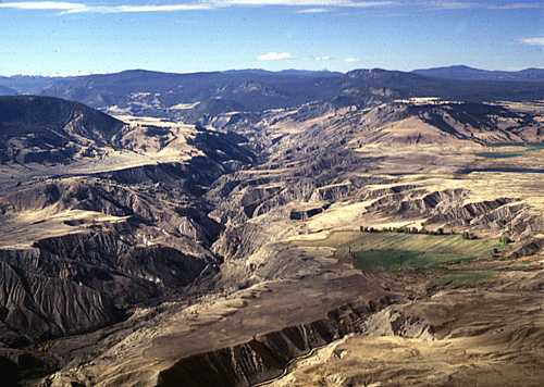
 Fraser Plateau (southern part of Central Plateau and Mountains Region): view westward up Churn Creek near the Gang Ranch. The gentle slopes of the upland surface (distance) and thick glacial drift (foreground) have been dissected due to down-cutting by Churn Creek since the last glaciation.
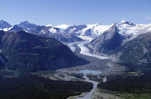
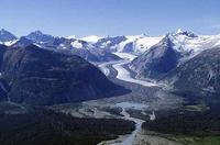 Boundary Ranges (northern Coast Mts): view westward toward the Alaska Boundary (skyline) and Flood Glacier. The glacier holds back a lake in a tributary valley (behind the forested ridge, left middle-distance), but the lake water periodically spills out from beneath the glacier and drains through the channels visible in the foreground. Glacier outburst floods such as this are a serious, although rare, hazard in parts of the Coast Mts. GSC photo 1998-032.
 -
Charts and graphs
-
Maps